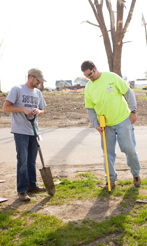
Instructor Kory Allred (right) and NIU student Jeremy Daehne search for buried property corner markers
to re-survey parcels of land in Fairdale.
A Northern Illinois University instructor and four of his students played a unique role in helping the residents of tornado-devastated Fairdale begin restore their lives.
Geomatics instructor Kory Allred and his students, along with other members of the Illinois Professional Land Surveyors Association, re-surveyed parcels of land – a critical starting point in rebuilding homes.
“This all came about because of Shawn VanKampen, a longtime DeKalb surveyor,” Allred said.
“He recognized that a resurvey would be the first step to helping residents actually rebuild. Shawn worked with the city and county, and once the plans were in place, he approached me about getting students involved. My students jumped at the chance to help out.”
Allred and his students arrived a couple of weeks after the April 9 tornado, so most of the buildings that were ruined were already torn down and the debris gone, leaving just empty space.
Those conditions tested survey teams.
“The first thing we do in a survey is to look for the property corner markers that are in the ground, usually iron pipes or iron rods at or just below the surface. We rely on things like fences, buildings, tree/brush lines, sidewalks for assistance. And in a case like Fairdale, where all that was gone, damaged or obscured, we had to rely on other evidence and a little luck.”
Surveyors use geomatics – the science of measurement – for representation, analysis, management, retrieval and display of spatial data pertaining to the physical Earth and its human built environments.
While most people associate land surveyors using the traditional “A frame,” they also use high-tech equipment such as GIS, GPS, digital photogrammetry, satellite and terrestrial remote sensing to create a detailed picture of the Earth’s natural and man-made features.
The field experience allowed some of the students with no experience to see how surveyors can help in natural disasters and, Allred said, provided a glimpse of “the real world” unavailable in a class or a lab.
“These surveys were done to a professional standard, which is different than a lab setting, which allows me to watch the students make mistakes and learn from them. Some students got their first look at everyday field work, and even those with some experience were able to pick up a few tricks or tips.”
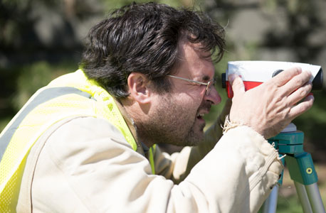
NIU geomatics student Tom Todd takes a distance measurement.
The experience in Fairdale illustrates the importance of mapping science, a field in which NIU is highly regarded.
Designed to prepare surveyors to sit for the state exam and become certified, NIU’s geomatics program goes beyond traditional training. It fully integrates land surveying (measurement) with GIS, cartography, remote sensing and spatial analysis for a broad, modern program.
Through a partnership with the Illinois Professional Land Surveyors Association, NIU also provides online exam review classes and continuing education for licensed professionals.
The profession offers the best of both worlds, Allred said: the ability to work out in the field and to conduct scientific and mathematical analysis in an office setting.
Geomatics also enables students to pursue a multitude of career paths. “Land surveying is just a jumping off point,” Allred said.
“Surveyors are active in many fields outside of the construction industry, including road construction, mapping wetlands, surveying waterways for shipping routes,” student Tom Todd said. “We’re not just the guy on the side of the road with a tripod.”
That variety of work, along with the ever-changing technology, is appealing to professionals.
“Since the advent of GIS, technology changes in a matter of months,” geomatics student Adam Harlow said. “If you aren’t using the latest platform in your measurements, it affects your accuracy. Small changes in plans can end up as big problems later on.”
The difference in precision between digital and analog instruments poses another challenge, Allred added. “Regardless of what type of instrument you’re using, if you set that instrument just a slight bit off, everything magnifies from there.”
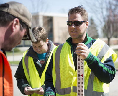
Mitch Top (holding the leveling rod) and Marcus Schmidt
consult with Tom Todd on a measurement.
But technology also opens new doors. Three of Allred’s students are also earning certificates in GIS, something that makes them more marketable.
“It gives a company more opportunities to grow,” student Marcus Schmidt said. “They need people to run the software, which is dynamic.”
For many, land surveying is a family affair.
“You either had a family member or a friend who was a surveyor or you took a class and caught the bug. Once in the field, surveyors stay in the field forever,” said Allred, who caught the bug as an engineering student.
Surveying truly was a member of the Todd family.
“My dad is a land surveyor, so I grew up with it,” he said. “My dad started his own company when I was little. He ran it out of his house, so we always had crews in the driveway heading out to projects. I want to get my license so I can take over the business when he retires.”
Others come into the field as a second career.
Geomatics student Jeremy Daehne was working at a civil engineering firm doing CAD drawings when his company had an opening. “They were looking for someone to work out in the field, so I volunteered,” he said.
“I was working in construction and got injured,” said junior Mitch Top. “I was able to go back to school, and I got interested in geomatics.”
Top says his stock has risen higher since he began studying GIS. He understands the coordinate systems and can enter them into the GIS database. “My company offers GIS services,” he said, “because I’m there.”
by Paula Meyer